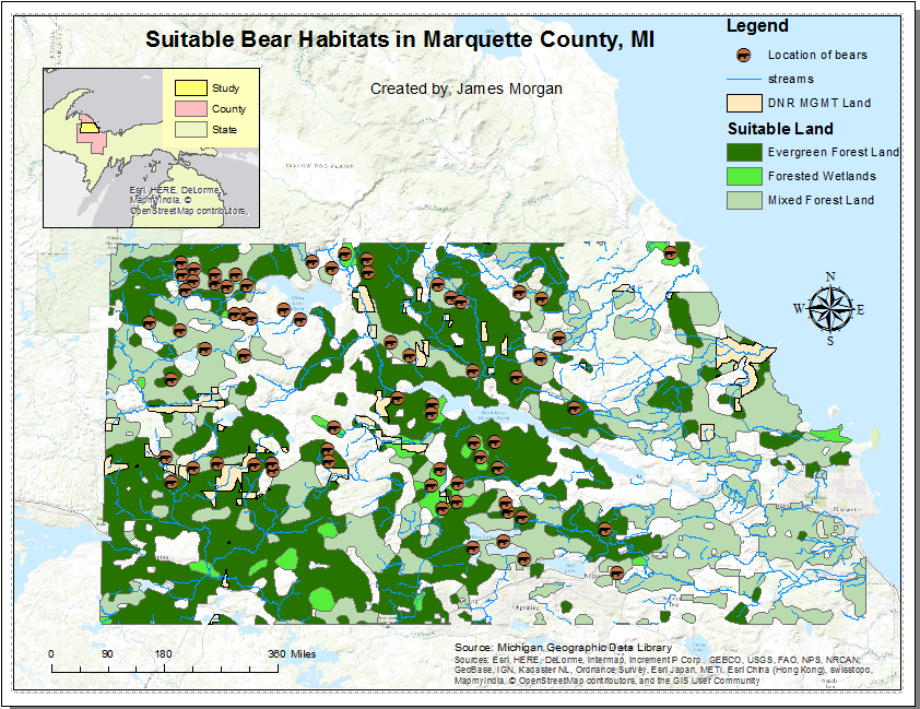
Goals and Background:
The goal of Lab 2 is to learn how to download and map data from the U.S. Census Bureau. In this lab there are 8 objectives displayed below:
1) Download 2010 Census data (total population) from the US Census Bureau.
2) Download a shape file of the 2010 Census boundaries from the US Census Bureau.
3) Combine the downloaded data to the Census shapefile.
4) Map the data.
5) Download and map a variable of your choice.
6) Make a layout with both maps
7) Create a web map with one of the variables.
8) Indite a technical report and post it to this blog.
In preparation for the lab read the definitions of US Census Bureau, Census Boundaries, Statistical Boundaries, Census Tract, Block Group, Census Block, 2010 SF1% Data, and lastly American Community Survey Estimates in order to learn some background knowledge.
Methods:
Objective One: Download 2010 Census Data:
Begin by creating a lab 2 folder in your the workspace for the class. The first step is to choose a data set form with advanced search on the US Census Bureau Fact Finder Website. Click on the Topics option, choose People , Basic Count/Estimate, and lastly population total. Now choose all counties within Wisconsin in the Geography option. Find the P1 for Total Population from the 2010 SF1 Dataset, download the data, and then unzip it in your Lab 2 folder. Next, extract all the files from the new unzipped folder in order to open the CVS files. Find the DEC_10_SF1_P1_with_ann.xlsx file in order to save it as a Excel Workbook. Then go back to the Census website to download the shapefile.
Objective Two: Download the shapefile for the WI census data:
Start by downloading the Map in the geographies option, and again unzip the file. You will need all the files, so don't move anything around. Use ArcCatalog to see and manage shapefiles.
Objective Three: Join the data together
Create a blank map in ArcMap titled Lab 2, and rename the Layers tab "Population". Bring in the 05000.shp shapefile, and the DEC_10_SF1_P1_ann$ attribute table. Join the tables using the common attribute field "GEO_ID".
Objective Four: Map the data
For this section a quantities graduated colors value for D001 needs to be made. However one must complete various steps to fix the original string field type. In order to fix this, create a new field named D001 in the 05000 attribute table. Go to the new field, and use the field calculator. Double click D001 then hit "Okay". Now you can create a map with graduated colors.
Objective 5: Map a Variable of your choice
Going back to the census website, choose a variable to download and map. Repeat the same steps as before in order to create the newly mapped variable.
Object 6: Build a Layout
For this section you will create a cartographically pleasing layout with both maps of Wisconsin. Put the two maps from Objectives 5 and 6 into two separate data frames in a landscape layout. Make sure each map includes a title, legend, north arrow, scale, date, source, and author. Include the year of the census from which you gathered the data.
Objective 7:
The last part of the lab involves sharing and configuring a map by creating a web map service in ArcGIS online. You also need to create a web map, and lastly configure that web map.
Publish the finished population map, and name it Wisconsin_Demographic_Information_Morgan in the UWEC Geography and Anthropology GIS online account. is complete you are asked to add a pop up in the Configuration window.
Results:
Objective 4:
After creating the new D001 Field you can create a quantities graduated color map that should like the map in Figure 1.
 |
Figure 1 is a map of the D001 field
for Total Population |
Objective 5:
Just like objective 4 you used D001 to create a quantities graduated color map, but this time it was with a variable of your own choice. Figure 2 shows displays a map of the number of housing units in Wisconsin.
 |
Figure 2 displays a map of D001 field
for total number of Housing Units |
Objective 6:
This portion of the lab requires you to make the two maps from Objective 5 and 6 visibly pleasing (as shown in Figure 3.
 |
| Figure 3 shows two cartographically pleasing maps |
Objective 7:
Once you configure the pop-up in the Configuration window it will appear for any county you click on (as shown in Figure 4). This is the hyperlink to show proof of finished product:
http://uwec.maps.arcgis.com/home/item.html?id=fa3a20e0336b488a95c51ee20bcd657a
 |
| Figure 4 shows the pop-up configuration for the uploaded map |
Sources:
All Data was acquired from the US Census Bureau in 2010


